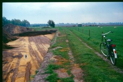
Archeologische opgraving: Kapelakker, Milheeze
Contact
Kapelakker
5763 AG Milheeze Plan your route to Archeologische opgraving: Kapelakker, Milheeze
Fortified medieval settlement of Milheeze. The Kapelakker excavation included a path about 1,000 years old, which probably ran through the Peel to Limburg. The path moved slightly over time but was still in use.
We knew Milheeze had a rich history and existed as early as 1332, then it is mentioned in old documents. It i…
Fortified medieval settlement of Milheeze. The Kapelakker excavation included a path about 1,000 years old, which probably ran through the Peel to Limburg. The path moved slightly over time but was still in use.
We knew Milheeze had a rich history and existed as early as 1332, then it is mentioned in old documents. It is then called Milleis. The name may come from hese, which means bushes, and mil or meijler, which has to do with places where charcoal is made. But now it turns out that as early as the Iron Age, which ran in the Netherlands from 800-12 BC, there was habitation in Milheeze. And from the year 400 onwards, Milheeze was inhabited again. That is one of the conclusions from archaeological research by archaeologist Theo de Jong. The most important find was a fortified settlement from the period between the ninth and 12th centuries. According to De Jong, there is a temporary boundary extension that turns into a pile enclosure with perhaps a gatehouse on the north side. In the south of the Netherlands, there was only one other place where a fortified 'village' like the one found in Milheeze was located. That was in the Eindhoven district of Blixembosch.
The Archaeological Center Eindhoven started an investigation at Rooiweg-Kapelakker in late April 2005. A test drilling in August 2004 had already found traces of habitation from the Middle Ages. "It was a very interesting survey, especially on the southern edge," according to De Jong. Over a thousand shards and traces were found, including a very special find: a 2.5-centimeter piece of glass bead from the Merovingian period (the year 400). These are rarely found; glass was an expensive luxury product.
A cart track from the time of 1050-1200 was also clearly visible in the excavation. This cart track was one of the few thoroughfares through the Peel to the east towards Venray. Many post traces were also discovered, including a building in the shape of a boat, residential farms and outbuildings where grains were stored. Furthermore, several wells were found that occur up to the end of the eleventh century. The part where the investigations took place was certainly inhabited until the year 1200. Then the inhabitants moved to lower ground to use high ground for arable farming.

